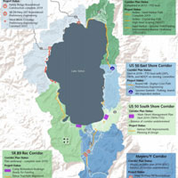
LAKE TAHOE, Calif./Nev. – Giving people a positive experience as they travel along the west shore of Lake Tahoe will require removing congestion from the roadway is one of the goals of the State Route 89 Recreation Corridor Management Plan.
A collaboration of 17 agencies and organizations have been working on the plan which covers the stretch from 15th street in South Lake Tahoe to the Placer County line at Sugar Pine Point State Park. Along the plan area are popular areas to view scenery, hike, bike and visit beaches along a 12 mile stretch of undeveloped shoreline.
During the recent Tahoe Regional Planning Agency (TRPA) meeting a briefing on the plan’s working group progress was presented by their Sustainability Program Coordinator Devin Middlebrook.


